Inwangsan
A granite hill on the old city wall near Gyeongbokgung Station, with views over central Seoul day and night
Intro
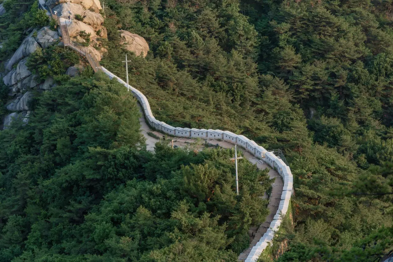
Inwangsan is a granite hill of about 340 m in central Seoul, between Jongno-gu and Seodaemun-gu (339 m on the City Wall website, 338.2 m in the Seoul hiking guidebook). Its rocks have names, among them Seonbawi, Chimabawi and Beombawi, and from the summit the old city spreads out around Gyeongbokgung Palace, with Bugaksan, Namsan and Naksan around it. It is the mountain of Jeong Seon’s painting Inwang Jesaekdo. The Seoul City Wall runs along its ridge. After the January 21 incident of 1968 the area was closed to civilians; the wall section opened in 1993, and the guidebook notes more of the mountain reopened in 2018.
It is a real summit you can walk to from the subway: start at Gyeongbokgung or Dongnimmun Station, reach the top in a little over an hour, and come down into Seochon for lunch or coffee. At dusk the lower path to Mumudae is one of the city’s official night-view spots. For other mountains in the city, see Hiking in Seoul.
Which route?
| Route | One way | Start | Level |
|---|---|---|---|
| Seonbawi route (to the summit) | 1.84 km, 1 hr 10 min | Dongnimmun Station Exit 2 | Average |
| City Wall, Inwang section | about 4 km, 2 to 2 hr 30 min | Donuimun Gate site (Seodaemun Station Exit 4) or Changuimun Gate | Average |
| Jarak-gil path (via Mumudae) | 2.73 km, 1 hr 10 min | Sajikdan Altar (Gyeongbokgung Station Exit 1) | Easy, no hiking boots needed |
| Forest path (via Suseongdong Valley) | 2.9 km, 1 hr 30 min | Sajikdan Altar | Steep steps at Gaon Bridge |
- Shortest way to the top: the Seonbawi route from Dongnimmun Station passes Inwangsa Temple, Seonbawi Rock and Beombawi Rock on the way to the summit. The guidebook says Beombawi is more popular than the summit for sunrise and sunset, and that the path from Beombawi to the summit is narrow. Seodaemun Prison History Hall is by Exit 5 of the same station; see Seodaemun Prison History Hall and Independence Park.
- The whole wall: start at the Donuimun Gate site, pass the Inwangsan wall rest area, go over Beombawi and the summit, and come down to Yun Dong-ju Poet’s Hill and Changuimun Gate. After the rest area the path splits three ways; the middle one goes to the summit, and the final stretch is a short, easy rock scramble.
- No summit, just views: the Jarak-gil path from Sajikdan stays on the lower slopes and passes Mumudae; the Chosochaekbang book cafe is nearby on Inwangsan-ro.
Night views
Mumudae Observatory on the Jarak-gil path is one of Seoul’s official night-view spots, and you can reach it in sneakers. The wall around Sajik Park is landscaped and lit, so it looks good after dark too. The mountain is open 24 hours, but the ridge is bare rock, so for an evening visit the Jarak-gil path is the easier choice.
Before you go
- Toilets and water: once you are on the wall or the ridge there are no toilets, and the City Wall website says there are none for about 2 hours after you set off and no convenience stores either. Use the toilets at the start (the last one on the Seonbawi route is next to Inwangsa Temple) and carry water and a snack.
- Winter: Inwangsan is mostly rock. On the City Wall trails (Inwangsan and Bugaksan), the City Wall website says to wear gloves and a warm hat in winter and crampons when it snows. The Seoul hiking guidebook says crampons are essential on Seoul’s mountains from winter to early spring, because many sections freeze, and that the spring thaw from March is the hardest time to hike.
- Gear: the nearest rental is the Seoul Hiking Tourism Center at Bugaksan, in Samcheong-dong (card below). The center has an English guide PDF for Inwangsan.
After the hike
- Into Seochon: come down by Suseongdong Valley to Okin-dong and you are at the top of Seochon, the old neighborhood west of Gyeongbokgung. For places to eat and drink there, see the Seochon sections of the food map and the cafe map. Tosokchon Samgyetang (card below) is the Seoul hiking guidebook’s pick for Inwangsan.
- Out the other side: from Changuimun Gate you can walk into Buam-dong, or keep going on the wall: the Bugaksan section of the City Wall starts at Changuimun. See Hiking in Seoul for Bugaksan.
How long to spend
About 2 hours for the Seonbawi route up and back down, and about 1 hour 10 minutes for the Jarak-gil path; 2 to 3 hours for the whole wall section. Add an hour or two in Seochon afterwards for a half day.
Get There
-
Gyeongbokgung StationLine 3
- Korean
- 경복궁역
- Exit
- Exit 1
- Walk
- 10 min
To Sajikdan Altar, the start of the Jarak-gil and forest paths and a way onto the wall.
-
Dongnimmun StationLine 3
- Korean
- 독립문역
- Exit
- Exit 2
- Walk
- unconfirmed
For the Seonbawi route, the shortest way to the summit. Walk toward the Muak-dong community center.
-
Seodaemun StationLine 5
- Korean
- 서대문역
- Exit
- Exit 4
- Walk
- 5 min
To the Donuimun Gate site (by Kangbuk Samsung Hospital), the start of the full City Wall section. Follow the City Wall signs.
-
Changuimun Gate (by bus)
- Korean
- 자하문고개·윤동주시인의언덕
- Exit
- unconfirmed
- Walk
- unconfirmed
From Gyeongbokgung Station Exit 3, take a bus to the Jahamun Pass and Yun Dong-ju Poet's Hill stop, then walk 2 minutes. The north end of the City Wall section.
Hours & Fees
- Hours
- Open 24 hours, every day
- Admission
- Free
- Toilets
- None on the wall and ridge once you set off; use the toilets at the start. The last one on the Seonbawi route is next to Inwangsa Temple; the Jarak-gil path has one past Hwanghakjeong
Places in Inwangsan
-
Inwang section of the Seoul City Wall
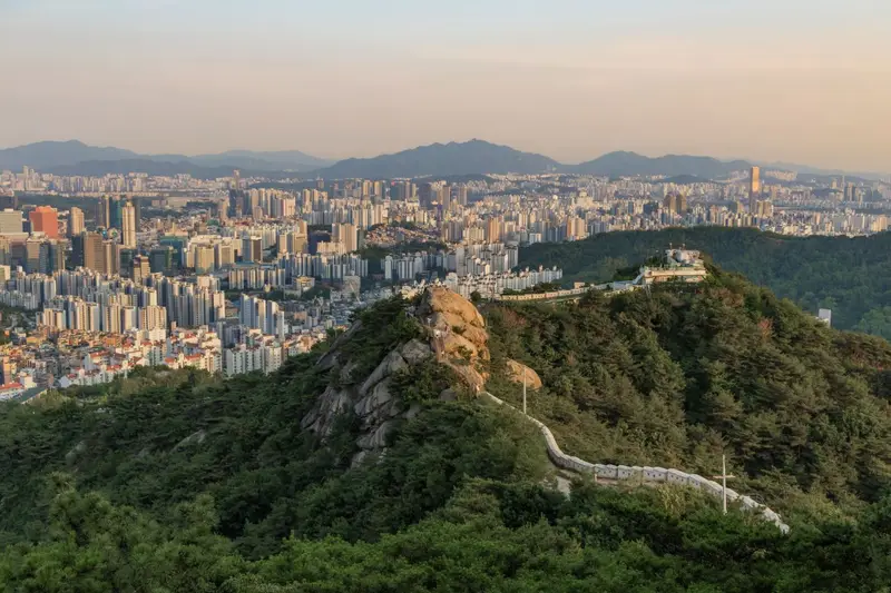
The classic walk: from the Donuimun Gate site along the wall past Beombawi Rock and over the summit, then down to Yun Dong-ju Poet's Hill and Changuimun Gate. About 4 km and 2 to 2 hours 30 minutes (4.0 km and 2 hours 30 minutes on the City Wall website, 4.1 km and 2 hours 10 minutes in the Seoul hiking guidebook). The last part before the summit is a short, easy rock scramble.
- Hours
- Open 24 hours
Foreigner access
Google Maps for Inwang section of the Seoul City Wall Naver Map for Inwang section of the Seoul City Wall- Korean name
- 한양도성 인왕산구간
- Booking
- No reservation needed
- English
- Signs: unconfirmed
The Seoul Hiking Tourism Center publishes an English guide PDF for Inwangsan.
-
Mumudae Observatory and the Jarak-gil path
An easy path around the lower slopes, from Sajikdan Altar past Hwanghakjeong archery pavilion and the Mumudae Observatory to the Yun Dong-ju Literature Museum, 2.73 km and about 1 hour 10 minutes; no hiking boots needed. Mumudae is one of Seoul's official night-view spots, reachable in sneakers, looking over Seochon's roofs and the city center. There are no shops on the path, so bring water.
- Hours
- Open all the time
Foreigner access
Google Maps for Mumudae Observatory and the Jarak-gil path Naver Map: unconfirmed- Korean name
- 무무대 전망대
- Booking
- No reservation needed
- English
- Signs: unconfirmed
-
Suseongdong Valley
A rocky stream valley in Okin-dong, Seochon, painted by Jeong Seon in his album of eight views of Jangdong. Apartments built here in 1971 hid it for 40 years until they were removed and the valley was restored. The forest path from Sajikdan passes through it (2.9 km to the Yun Dong-ju Literature Museum, about 1 hour 30 minutes, with steep steps at Gaon Bridge), and it is a way down into Seochon.
- Hours
- Open all the time; no parking
Foreigner access
- Korean name
- 수성동계곡
- Booking
- No reservation needed
- English
- Signs: unconfirmed
-
Inwangsan Chosochaekbang (book cafe)
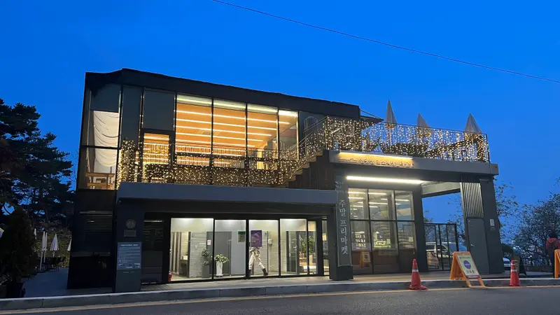
A glass-walled book cafe made from a police guard post built after 1968 to protect the presidential residence, with a view toward N Seoul Tower. A rest stop on the lower slopes, open into the evening.
- Hours
- 8:00 to 22:00 daily, last order 21:30
- Prices
- Americano 4,900 won, cafe latte 5,900 won, vanilla or oat latte 6,500 won
Foreigner access
Google Maps for Inwangsan Chosochaekbang (book cafe) Naver Map for Inwangsan Chosochaekbang (book cafe)- Korean name
- 더숲 초소책방
Foreigner access details not yet confirmed
- English
- No parking.
-
Yun Dong-ju Literature Museum
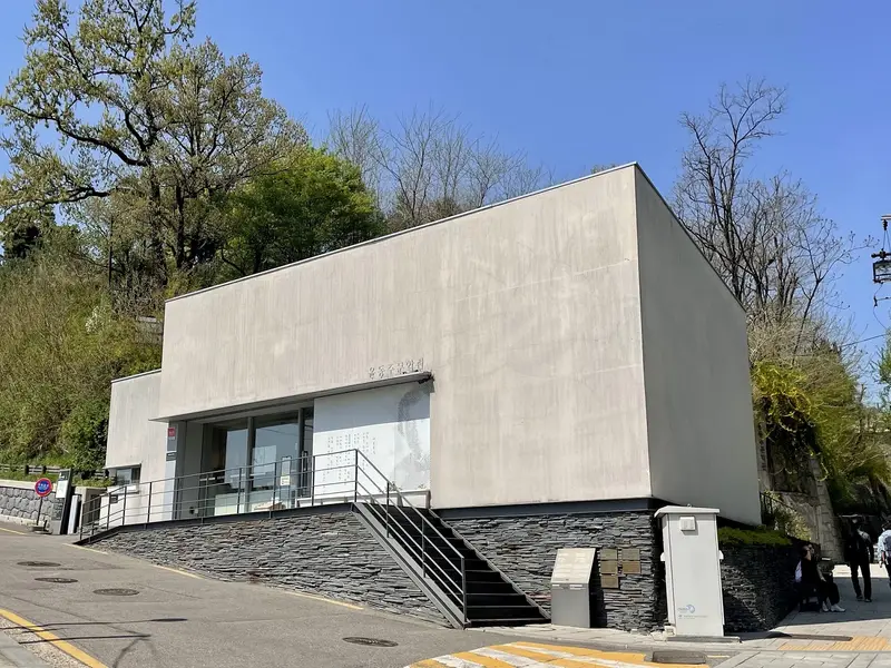
A small museum for the poet Yun Dong-ju, who lodged in nearby Nusang-dong as a student and is said to have climbed Inwangsan while writing. It opened in 2012 in a disused water pressure station and its tanks, at the end of the Jarak-gil and forest paths; Yun Dong-ju Poet's Hill, on the City Wall route, is next to it.
- Hours
- 10:00 to 18:00 (last entry 17:30), closed for cleaning 13:30 to 14:00; closed Mondays, January 1 and on Seollal and Chuseok days
- Admission
- Free
Foreigner access
- Korean name
- 윤동주문학관
- Booking
- No reservation needed
- English
- Signs: unconfirmed · Staff: unconfirmed
-
Tosokchon Samgyetang
Ginseng chicken soup (samgyetang) near Gyeongbokgung Station since 1983, which the Seoul hiking guidebook picks as the place to recover after Inwangsan.
Featured on Seoul Tourism Organization, Seoul Hiking Tourism Guide Book
- Hours
- 10:00 to 22:00 daily (last order 21:00)
- Prices
- Samgyetang 20,000 won, lacquer-tree chicken soup (otgyetang) 20,000 won, black chicken samgyetang 25,000 won, seafood pancake 17,000 won, rotisserie chicken 19,000 won
Foreigner access
- Korean name
- 토속촌삼계탕
Foreigner access details not yet confirmed
-
Seoul Hiking Tourism Center (Bugaksan)
The nearest place to rent hiking boots, clothes, backpacks, gloves and poles as a foreign visitor, with lockers, changing rooms and a hanok lounge with free tea. It is in Samcheong-dong, about 24 minutes' walk from Gyeongbokgung Station Exit 4, not at an Inwangsan trailhead. Phone 1533-2158.
- Hours
- 9:00 to 18:00, closed Tuesdays and on Lunar New Year and Chuseok holidays
- Rental prices
- unconfirmed
Foreigner access
Google Maps for Seoul Hiking Tourism Center (Bugaksan) Naver Map for Seoul Hiking Tourism Center (Bugaksan)- Korean name
- 서울 등산관광센터 북악산
- Booking
- Rental booking on Klook, linked from the center's English website
Korean phone number needed: unconfirmed - English
- Signs: unconfirmed · Staff: unconfirmed
English website and English guide PDFs. Rental is for foreign visitors and Koreans with them.
Hotels
Experiences
Sources
- Seoul City Wall: Inwang section (route, hours, access, toilets, winter) (accessed 2026-11-12)
- Seoul City Wall: Baegak section (accessed 2026-11-12)
- Seoul City Wall: notes for walkers (no toilets or shops) (accessed 2026-11-12)
- Seoul Tourism Organization: Seoul Hiking Tourism Guide Book (English, December 2024) (accessed 2026-11-12)
- Seoul Hiking Tourism Center: Inwangsan guide (PDF) (accessed 2026-11-12)
- Seoul Hiking Tourism Center: Bugaksan center guide (PDF) (accessed 2026-11-12)
- Seoul Hiking Tourism Center (English) (accessed 2026-11-12)
- Korea Tourism Organization: Inwangsan (accessed 2026-11-12)
- Korea Tourism Organization: Inwangsan Mumudae Observatory (accessed 2026-11-12)
- Korea Tourism Organization: Inwangsan The Forest Chosochaekbang (accessed 2026-11-12)
- Korea Tourism Organization: Suseongdong Valley (accessed 2026-11-12)
- Korea Tourism Organization: Yun Dong-ju Literature Museum (accessed 2026-11-12)
- Seoul Media Hub: Bugaksan hiking center (2026-10-08) (accessed 2026-11-12)
- Naver Place: Inwangsan (accessed 2026-11-12)
- Naver Place: The Forest Chosochaekbang (accessed 2026-11-12)
- Naver Place: Yun Dong-ju Literature Museum (accessed 2026-11-12)
- Naver Place: Suseongdong Valley (accessed 2026-11-12)
- Naver Place: Changuimun Gate (accessed 2026-11-12)
- Naver Place: Sajikdan Altar (accessed 2026-11-12)
- Naver Place: Seoul Hiking Tourism Center Bugaksan (accessed 2026-11-12)
- Naver Place: Tosokchon Samgyetang (accessed 2026-11-12)